We planned to return this year, and this time I decided to take a bike. After doing a little research, I had a basic plan.
The first thing you have to do is buy a membership to the Catalina Island Conservancy. The lowest level is "Friend" and it will cost you $35 for a year. This is a requirement to ride into conservancy land, but I really don't know how well it is enforced. Humans are pretty scarce once you ride through the conservancy gates into the interior.
Except for the rich and/or famous, who might take a helicopter or small plane, the island is generally accessed via ferry. There are a few ports to start from and a couple different companies. We chose Catalina Express because we qualify as seniors (55+ is a $3.50 savings per leg) and taking a bike was only an additional $3.50. The Catalina Flyer charges $20 for a bike, so that was an easy choice.
I considered the terrain, which was supposedly smooth dirt roads, and chose my Jones Plus LWB for the trip. It had balding tires, a terribly worn chain and chainring, and wasn't running well in general. After replacing some parts and a tune-up, it was ready to go.


As the ferry neared Avalon, we were required to go inside the cabin. Again, the guy wanted me to leave it in the rack where it would undoubtedly fall over and bend something. After some back and forth, he let me lay it on the ground next to the rack. I kept my composure. Mostly.
Once off the boat, we made our way towards the condo. One thing about Catalina that I have yet to figure out is how 69 degrees can feel so hot. My son and I continually looked at our weather apps and were consistently surprised by the low temperatures. We've been to Florida, Hawaii, all around Mexico, up and down the California coast, and nothing seems to compare. Weird. I will say that even the locals were commenting on the higher humidity due to the incoming hurricane. Anyway, after a 15 minute walk with our very heavy backpacks, we made it to the condo. My bike found its resting place for the rest of the trip.

The next thing on the cycling to-do list is to acquire a bicycle permit. Again, this is required to enter into the interior, but free with your conservancy membership. Jennifer and I went to the conservancy office where the guy gave me the requisite "don't pet the bison" speech and provided a short virtual tour of the island on a map (a copy of which I purchased for six bucks). He asked where I intended to ride the next day, and I told him I would start with a ride to the airport. He traced a route naming off streets, which I would never remember, and pointed to a particular road and said, "Here you'll be walking." I responded with, "That ain't happening." He then assumed I had an eBike and Jenn laughed. "No, he hates eBikes." Well, hate is a pretty strong word. I simply prefer the challenge of riding a bike with no motor. And I think anything with a motor ceases to be a bicycle.
With permit in hand we headed back to the condo for a little rest before dinner.

The next morning I headed out for a ride to the airport. The basic profile is pretty simple: Climb to the top of the island spine, ride along the ridge, and gradually reach the high point at the Airport in the Sky.

After rolling slightly downhill from our condo to the bay, the fun starts. The first climb is on a paved road and averages about a 9.5% grade for three miles. Google routed me up Chimes Tower Road, which turned out to be a one-way street, so be aware of that. The correct way to go up is on Stagecoach, also a one-way road, which I did on subsequent rides.
Conditions were cool (64 degrees) and foggy, yet it felt very warm. Within minutes I was hot and sweating profusely as I climbed up the steep road.
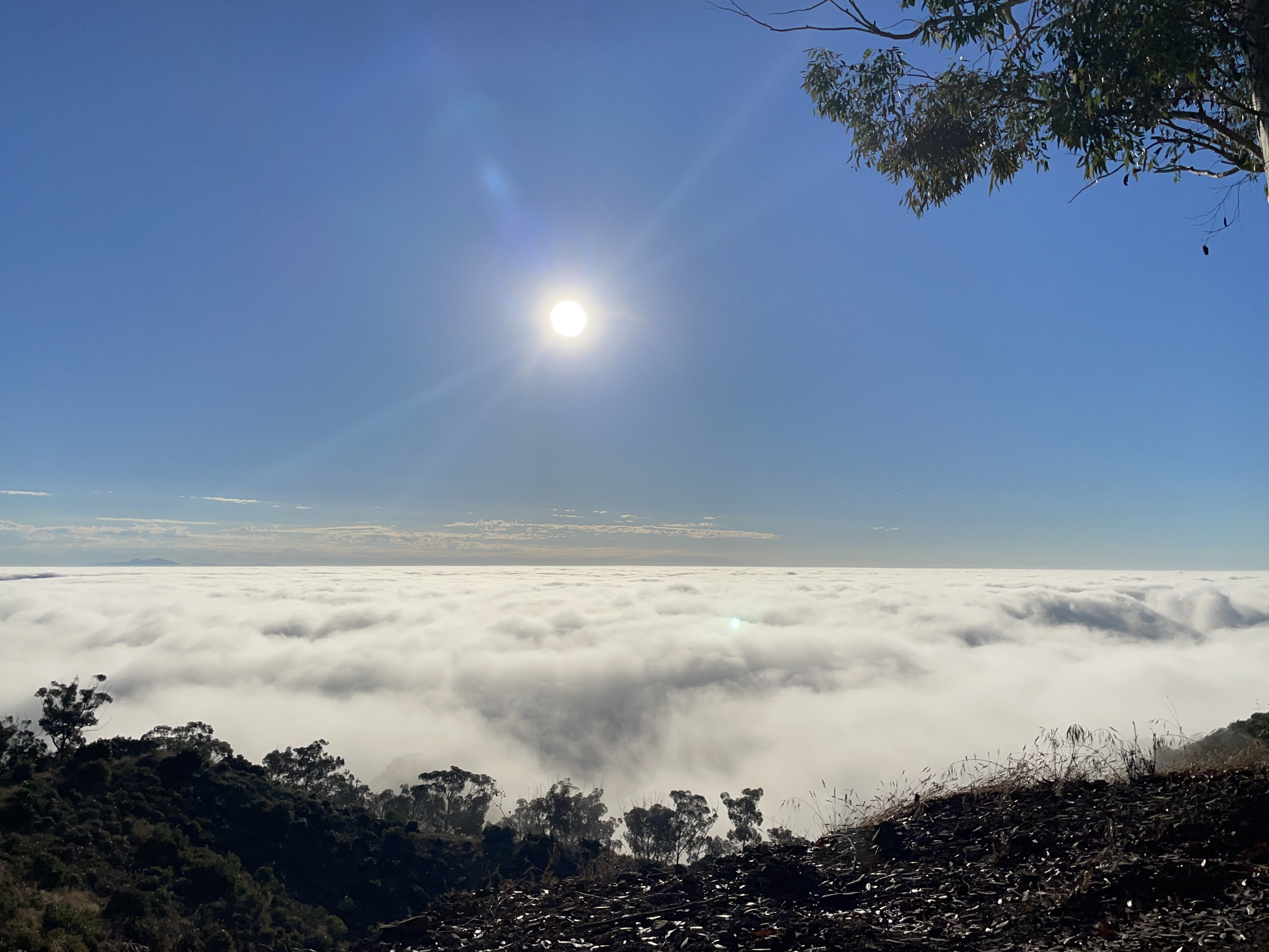
Views were obscured by the fog on the way up, so I did not stop for pictures. I rode straight through to the airport, although I did shoot a few "no-hands" pictures on the fly once I climbed above the fog.
Once you reach the top of the climb, the road turns to dirt for a while. From what I have seen, this is the case for almost all the roads on the island outside of Avalon. Only the road to the airport features any asphalt. For the most part, these roads are graded frequently and are often smoother than the paved road.

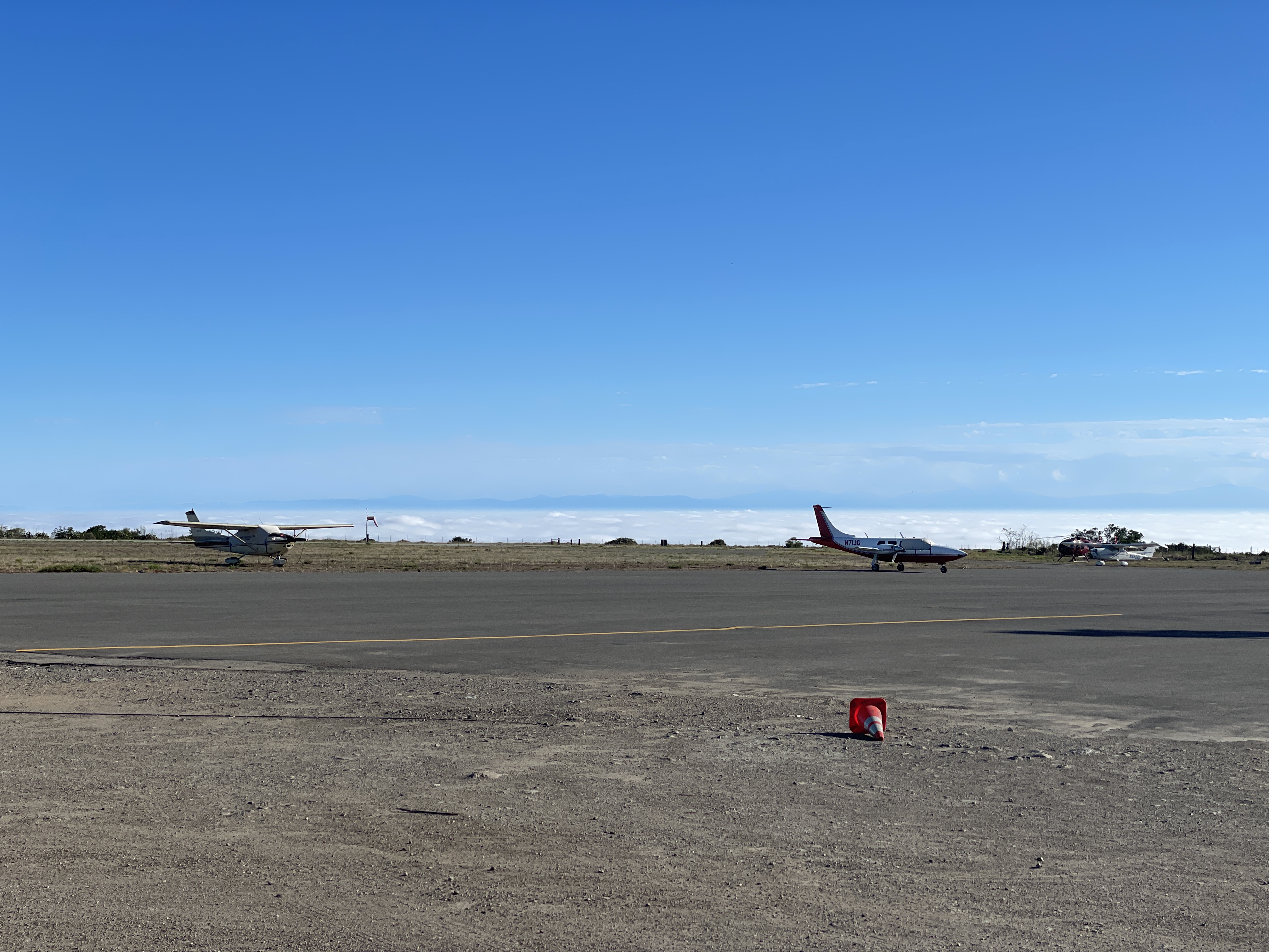
The airport itself is pretty cool. I guess options are limited when the island is basically a mountain peak jutting out of the sea. The only flat spot they could find is up over 1600 feet and 10 miles from Avalon. I can only imagine it's fun to land here.

The fog deck below the airport made for some interesting photos.

The obligatory bike shot:

It was really bright up there, so I failed to notice that the posted elevation (upper right) was out of the frame. Next time.
On the way back I stopped for more pictures since the fog was burning off. Here are the famous island bison in the distance:

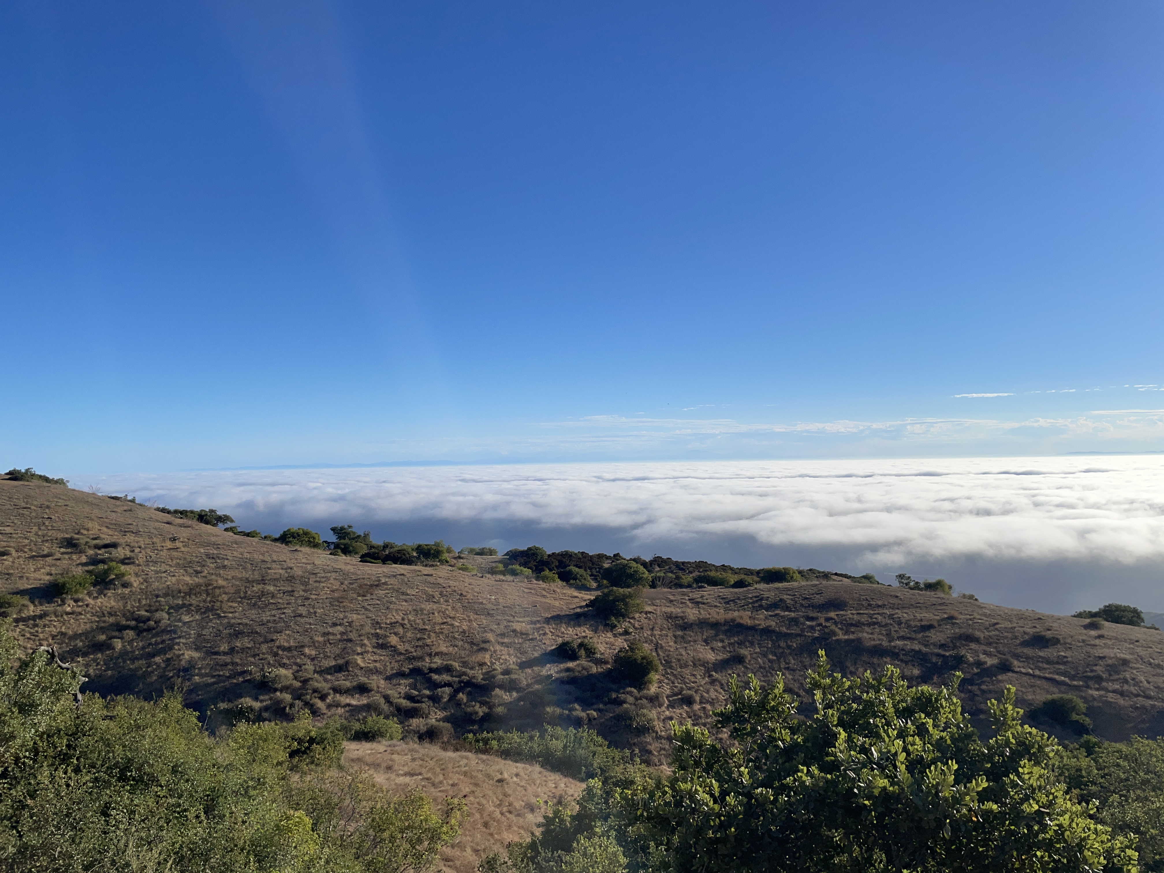
And various views from the ridge:


The ride down was fun, but keep in mind that even in the early morning there will be occasional cars on the narrow road, and golf carts as you near the end. The road surface is rough in places, with blind corners, so keep your speed in check. I maxed out at 30 miles per hour, but I could have easily hit 40 or more. As the day progresses, riders on eBikes, along with buses and jeeps full of tourists, will also be on the road. My advice here is to get out early to avoid the traffic.
Once back, the round trip totaled 20.64 miles with 2520 feet of climbing.
■ ■ ■
And now a slight detour from the cycling content. Later that day we took a little side trip up to a picturesque place to "pick up trash." This is an activity that Grayson and Sierra came up with to leave places they visit in a better place than before they arrived. It's an awesome tradition.

But there was really another motive for being in that place:


Congratulations to Grayson and Sierra!
Everybody went and it was a great way to end the day.


■ ■ ■
The next day was a planned day off the bike. Jennifer and I went on a morning hike on a trail I found a couple years ago. It wasn't a terribly strenuous hike, but the elevation gain offered some nice views of Avalon.

We returned to find most of our party (ten people in all) heading to the beach. I am not a beach guy, so with nothing better to do I decided on a short ride.
Short is relative, of course. At our new home in Folsom, short is 20 miles with a negligible elevation gain. On Catalina, 20 miles is a serious commitment.
I took off with no route in mind, which is evident from the map:

As you can see, lots of wandering and doubling back. I was on asphalt most of the time, although I was scouting out dirt options for the following day.
The climb on Stagecoach gave me some Vuelta a España vibes.

The long grind up the ridge:

Since it was later in the day, the views were mostly fog-free.


I finished with a paltry 11.73 miles but 1440 feet of elevation gain.
■ ■ ■
On day three I decided to explore East End Light Road, which is a dirt path off of Wrigley Road. On my map it appeared to be a bike legal route, and a sign confirmed that when I arrived at the trailhead. I had aspirations of doing a loop, but I wanted to see how I felt after the first climb.

Like pretty much any ride here starting in Avalon, there is nowhere to go but up:
.png)
It was a foggy start. Here is a view of Avalon from sea level looking north:

Once on the dirt climb it was immediately apparent this road wasn't graded as often as others. It was loose, rocky and had washboards in almost every corner. I saw few tracks of any kind, suggesting the road wasn't used much.
One cool thing about islands is how they can have little microclimates depending on elevation, geological features and cardinal direction. This valley was lush and jungle-like, reminding me of the scenery in Jurassic Park. Adding to the visuals was an eerie groaning echoing through the valley, which sounded a lot like the T-Rex from the film franchise. Creepy. It turned out to be some noise emanating from the power plant, but it shook me for a few seconds. Not gonna lie.


As I neared the top, Avalon came into view. This is from a height and perspective that few people probably see:

When I reached the top I had to decide whether to descend down an unknown road and attempt to find a legal way back to Avalon (which may have required another big climb) or play it safe and retrace my route. Even with a Catalina trail map, it's tough to know if a road or trail is bike legal until you actually see the sign.
Since I was going on another hike, I opted to play it safe and head back the way I came.
Unfortunately the fog obstructed what would have been a great panoramic view:

A note on all the "dirt" you see on Catalina:
If you use Google Earth to scout out dirt riding routes as I do, be aware that Catalina features both dirt roads and fire breaks. Santa Catalina Island has a long history with wildfires, so firebreaks are numerous. As you can see in the panoramic shot above, a fire break parallels the road. These breaks are soft and generally not rideable, often going straight down the sides of hills. Unfortunately they look just like roads on Google, so take care not to think you found a route that isn't really viable.
The descent back down was a little loose and rough. While I enjoyed the descent I had earned, it would have been a lot more fun on a hardtail.
I finished the ride with another meager total of 11.29 miles but with 1788 feet of climbing.
On our hike, my legs were a little weary. Here Jenn catches me resting:

■ ■ ■
On day four I woke up a little tired. My original plan was to ride to Little Harbor, but I knew this would entail at least two major climbs and probably 5000 feet of elevation gain or more for the loop. I didn't know if I had it in me. I opted to start with another climb to the airport and take it from there.
The climb up to the airport was pretty much the same, except this time I used the directional roads correctly. The pace was slow to start, but once I warmed up I felt better. I arrived at the top in 1:28, only three minutes slower than day one.
Given a second chance, the new picture includes the elevation:

On the way back down I took my time and enjoyed the scenery, serenity and solitude. The terrain is awe inspiring, even the second time.


Occasionally a local will interrupt the tranquility, but that's okay.

That's an island fox. It is closely related to the gray fox from the mainland, but much smaller. Six of the eight Channel Islands are inhabited by a subspecies of the island fox unique to the island it lives on. As tiny as this fox was, the Catalina subspecies is actually the largest of the six.

I have a soft spot for crows and ravens. This large raven could probably eat an island fox whole.

I briefly entertained going down Middle Ranch Road, but chickened out after 100 yards when I saw how fast the road was dropping away from the ridge. I just didn't want to do another big climb.

I completed the descent into Avalon and did a little more exploration of the areas to the north that I hadn't seen. I added one more climb up Wrigley Road just because the downhill is so enjoyable and finished up with 26.48 miles and 3222 feet of climbing.
■ ■ ■
After the ride, I told Jennifer I needed to find some sort of straps to tie down the bike for the return ferry trip the next day. She suggested zip ties, which was a great and simple idea that hadn't occurred to me. I went to the hardware store and bought a small package.
As we waited in line to board the ferry the next morning, we received a broadcast alert on our phones to vacate the island. Hurricane Hilary was getting close.

We boarded the ferry and I zip tied the front wheel to the left side of a tire slot. This kept the brake rotor out of harm's way and the bike remained upright and safe for the entire trip.


We said goodbye to Catalina, at least for now.

A few notes:
Cruise ships come in on Tuesday and Wednesday. This obviously increases the number of people on the island. Schedule accordingly when making plans to dine, rent equipment or participate in any organized activities (zip line, snorkeling trips, tours, et cetera).
There is one grocery store, which is Vons on Sumner Street. The prices were a little higher for most food and substantially higher for beer. Still, we saved quite a bit of money by preparing some of our own meals in our rental condo.
As you might imagine, restaurants on an island literally have a captive audience; most are expensive. In the two years between our visits, a few went out of business and one changed from Italian food to American Cuisine, whatever the hell that means. I can't in good conscience recommend any of them except one, which is The Sandtrap. They have a happy hour every day (2-7 p.m.) when tacos are $2 each and also deals on beer and drinks. I probably ate there a dozen times between our two trips.

For a first trip with a bike I am fairly happy with the results. Next time I will consider a hardtail simply because the descents are so long. Even a smooth dirt road eventually fatigues your hands on a rigid bike.
I regret not doing a big loop, but I hadn't been on big climbs like these in a few years. As it turned out, I was in pretty decent shape and probably would have been fine. Next time.
Later.
Great insight to the island.
ReplyDelete